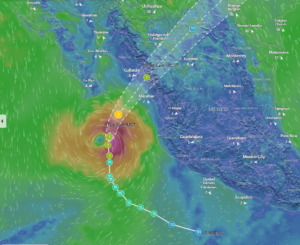
Hurricane Pamela is gathering strength as it travels northeast towards Mexico’s western coast. The U.S. National Hurricane Center is currently predicting the storm will develop into a Category 2 storm (or stronger) when it makes landfall near the state of Sinaloa, Mexico.
- The main coastal impact is expected Wednesday morning with the possibility of large destructive waves, 80 mph winds (or greater) and four to twelve inches of rain
- The Sinaloa growing region has very fertile agricultural land with a large allocation of crops used for export in the late fall/winter season
- A wide variety of items might be impacted including corn, tomatoes, bell peppers, squashes, and cucumbers
- The majority of the crops are already in the ground with the last plantings occurring two weeks ago
- Mid-tech greenhouses and shade houses are vulnerable to high winds and any fields saturated with rain might need to be replanted
- Markon will continue to monitor and update as more information becomes available.

Please contact your Markon customer service representative for more information.
©2021 Markon Cooperative, Inc. All rights reserved.